SECTIONS 18 – 24
Section 18
Concerning the inconvenient organization of Marinus when writing about the habitable earth.
§1. Therefore, what is owing to historical accounts and to certain things that have happened, has been set down so far with great diligence, and in order that we might not seem to have undertaken a censorious position and not to have judged fairly, it will be our guiding principle throughout to consider every part of the evidence, so that henceforward it will be an intellectual approach to the art of map–making.
§2. Indeed the substance of this kind of enterprise is twofold, first in turn, making an arrangement of the habitable earth as an overall spherical representation, and secondly, on a flat surface, and that which both sides have in common is being set down as serviceable and easy to use, that is it will explain, in what way and in a previously unavailable manner, an exact copy of maps, not existing before, might be made with absolute ease, from contemplation of commentaries alone. For, as always, the duplication from the original into existing representations is likely to produce, from changes or small variations, remarkable anomalies.
§3. And if it should come to pass that there is no independent evidence unearthed for this method of map–making, then we are unable to find the proper image and helpless to reveal a solution. It has happened very many times with the maps of Marinus, they have not succeeded in completing a true copy of the original, attempting to do it offhand from commentaries and wrong data for the most part through collective agreement and the spreading abroad of misleading data, thus it will be quite easy in all cases to behold the error.

§4. For it is necessary to have found out where the longitudinal point and latitudinal point of every place happens to be, in order to fix its intended position in order. To discover this is not straightforward in his commentaries, their being separated at this point. It might happen to be the position of the latitudinal point as with the explaining of the parallel, in another place the position of the longitudinal point, just as with the writing down of the meridians. For the most part not each of the two parts themselves, but the writing down of one or the other of the parallels, or one or the other meridians, with the result that only one or the other position is marked out. Ideally each should be in its proper place but it is really necessary to inspect the commentary in its entirety since nearly always it makes reference about them elsewhere.
§5. And if we were not to seek after each particular location throughout the entire work, we would lose the memory of these, missing entirely the many observations that have come down to us.
§6. Yet in placing the positions of cities in their proper places, those lying on the sea shore would be the most easy to draw in outline, upon the whole there is a certain order of arrangement from him in placing them, not so those inland, in no way are these given the same indications toward the status as that given for the others, except in a small degree, where it happens, in one case to the longitude and in another case to the latitude, has been defined.
Section 19
Concerning a means leading towards a convenient way in which we can graphically represent matters.
§1. On which account we make known a twofold labour, one keeping to the purpose of the whole commentary from this man, apart from obtaining certain corrections, the other in order to show what had happened in bringing to light historical accounts that had not then been written down and because of much later, more accurate maps and more complete commentaries.
§2. In relation to this, attention should be paid towards a convenient method for the arranging of entire provinces both by mapping the places themselves, what position of longitude and latitude they hold, and what is most worthy of note about the inhabitants and their relation with others. Such as the most notable cities, rivers, bays, mountains and all else, bringing us towards accurately putting details on a picture of the habitable earth. That is to say how many degrees, (the great circle is three hundred and sixty such), of longitude, by drawing the meridian through the place, from the meridian marking the boundary of the west. In relation to the equator, or the latitude itself, by drawing the parallel through the place, from the equator as marking the base point and intersecting that same meridian.
§3. For with these we have the ability to diagnose straightaway a position for every specific place, and through them, establish an accurate position of the provinces and their reaction to others and towards the whole inhabited world.
Section 20
Concerning the asymmetrical nature of the geographical maps by Marinus.
§1. Each map–making enterprise would seem to be idiosyncratic, because to make it so that it has the shape of the earth itself, by inscribing on to a sphere, there is no necessity for something in the nature of a contrivance of any kind. Yet is it not convenient to supply space large enough to make room (on a sphere) for the many details that need to be included within, or be able to fasten ones sight on the whole appearance of the enterprise at one and the same time. But it is necessary to move one or the other, that is, either the eye or the sphere, applying each successively.
§2. Where it has been encompassed entirely on a flat surface, this method seeks after some other kind of representation of the image on a sphere, in order that the distances represent themselves in due proportion especially in accordance with the actual distances on the surface.
§3. Indeed Marinus not only happens to bring attention to this, but in general reproaches any method that does not inscribe on a flat surface, having experimented with it himself, and not himself accepting it as being a suitable method, especially for declaring distances in due proportion.
§4. For instead of circular lines for parallels and meridians straight lines are placed together in order, and one longitudinal or latitudinal line to another are always parallel.
5. Only the latitudinal line through Rhodes itself has been observed in relation with the longitudinal line, equalling nearly one fourth of the circumference of the sphere of the great circle towards the parallel and distant from the equator by thirty–six degrees. For others he displays no thought, neither on account of proper proportion nor to their spherical aspect.
§6. For only by fixing the eye on the middle of the fourth part to the north of the sphere, in which the most part of the habitable world is registered, can the longitudinal lines be made to represent a semblance of straight lines, whenever it is turned around and top of each line brought down opposite on a level with the eye itself. This cannot be if, as in the juxtaposition of the North Pole with the latitudinal lines, segments of the circle clearly hang upon the convex surface converging towards the lines of longitude.
§7. Next, according to the truth and according to what is apparent in itself, the same lines of longitude, intercept unequally spaced lines of latitude, that differing in length from each other, always make themselves greater the nearer they are to the equator. However, the space of the climates, (that is the space between the lines of latitude), north of the latitudinal line through Rhodes, in truth extend more, as opposed to those of the south which are less. Thus those being set down upon the map cannot be made to coincide with their actual measured stadia. On the equator they leave behind one fifth of their particular portions, which is the proportion that the latitudinal line through Rhodes is less than the equatorial line of latitude. While that passing through Thule is itself four fifths that of Rhodes being the proportion that the latitudinal line of Rhodes is greater than that of Thule.
8. For as near as possible, the latitudinal line of the equator is set at a hundred and fifteen such parts and is distant to the south of that of Rhodes by thirty–six degrees. Correspondingly then, this will contain ninety–three such parts, while that of Thule, sixty–three degrees from the equator, requires fifty–two such parts.
Section 21
What it is necessary to observe for map-making on a flat surface to be made possible
§1. It would be best to ensure that any longitudinal line representing a meridian has straight lines and that latitudinal lines representing parallels themselves as being inscribed as a convex perimeter of a circle, itself inscribed around a central point, from under which, setting at the north pole, it is expected to carry the straight lines of the meridians. In order that in every way the nature of the sphere is maintained and made manifest and is being preserved as much alike as possible, it is emphasized that the meridians must stay in place and remain straight in regard to the parallels and yet share a common interception point at the pole.
§2. Since all of the parallels will not be able to observe the proportional representation of a sphere, it will have to be sufficient in itself to observe this both of the one through Thule and through that of the equator, in order that they happen to be proportionate and embrace the true extremes of latitude according to us. As regards that passing through Rhodes having been inscribed, from this many of the intervals between the lines of longitude have been proven, in regard to the true proportions into which it has to be divided, as indeed does Marinus. As well as in regard to the entire circumference, of which, as near as possible, it is one fourth, in order to make better known the longitude of the whole of the habitable earth.
§3. And while this way will work for this method, clearly, if we might accomplish this, it follows that we might also easily press on with what is necessary to inscribe on a sphere.
Section 22
How it is necessary to inscribe the habitable world on a sphere
§1. Concerning the size and number of the items in relation to the map contents being accommodated, which would be decided as being required,
just how it would be made would reflect the ability and the perfection of effort; as great as this might grow, then at the same time, pro rata, the finer, more distinct and perfect will be the cartography.
§2. However great the skill, having placed the poles themselves accurately we will then have to construct a semi-circular arm between them, fixing it independently a very little above the surface, so that it does not touch the surface itself while revolving.
§3. The semi-circular arm should be narrow, in order that its width might not cover very many places. In relation to the poles divide one side accurately marking them in such a manner as we might inscribe on to a meridians; to be placed at intervals made by one hundred and eighty divisions and mark the numbers down starting from the middle at the equator, these then having to be cut again from the other side of the equator.
§4. Similarly mark the line of the equator itself with a second semi-circular arm on which there are one hundred and eighty divisions marking the numbers down from the point of the most westerly of the meridians.
§5. Now we shall make the inscriptions from the written commentary for the positions written down for the longitudes and latitudes having been assigned for each place, and inscribe on the divisions of the equatorial semicircle and on the movable semicircle of the meridian the correct place. Moving this around to the degree of longitude so as to be against the number of the place on that encircling the equator that relates to the marking the distance of the latitude on the equator dividing the equator, by showing accurate numbers setting out to mark the direction as with stars on a solid sphere.
§6. Similarly it is possible to inscribe the meridians having been divided into as many as we would choose, in degrees of longitude, on the surface of a circle rather than a straight line from the side of a ruler. How many meridians must be provided and inscribed, in due proportion as belonging to the known world, should be signified along the line of the equator as far as the opposite side, marking off the boundary of the earth, by meridians.
Section 23
Explaining the categorisation of the inscriptions of meridians and parallels
§1. These, in accordance with what has been shown, are encompassed by an interval of twelve hours; the parallel having been inscribed and marking off the southern extremity is away from the equator as much as the parallel through Meroe is as much to the north. However we thought it to be more suitable to inscribe the meridians at intervals of one third part of an equinoctial hour, that is through five of the divisions held on the equator; and the parallels to the north of the equator are as follows.
§2. So that first is to differ one fourth part of an hour, separated from the meridian, which they suggest as being drawn and displayed as near as possible, four degrees and fifteen minutes.
§3. The second is to differ one half of an hour, similarly separated by eight degrees and twenty–five minutes.
§4. The third interval is to differ three quarters of one hour, separated by twelve degrees and thirty minutes.
§5. The fourth interval differs by one hour, separated by sixteen degrees and twenty–five minutes, being inscribed through Meroe.
§6. The fifth interval differs by one and a quarter hours, separated by twenty degrees and fifteen minutes.
§7. The sixth interval, and the one under the summer solstice, differs by one and a half hours, separated by twenty–three degrees and fifty minutes and is the one being inscribed through Syene.
§8. The seventh interval differs by one and three–quarters of an hour, separated by twenty–seven degrees and ten minutes.
§9. The eighth interval, and the one through Alexandria, differs by two hours, separated by thirty degrees and twenty minutes.
§10. The ninth interval differs by two and a quarter hours, separated by thirty–three degrees and twenty minutes.
§11. The tenth interval differs by two and one half hours, separated by thirty–six degrees being inscribed through Rhodes.
§12. The eleventh interval differs by two and three quarters of an hour, separated by thirty–eight degrees and thirty–five minutes.
§13. The twelfth interval, and inscribed through the Hellespont, differs by three hours, separated by forty degrees and fifty–five minutes.
§14. The thirteenth interval differs by three and one quarter hours, separated by forty–three degrees and five minutes.
§15. The fourteenth interval, and through the middle of the Pontus, differs by three and a half hours, separated by forty–five degrees.
§16. The fifteenth interval, and through the winter solstice, differs by four hours, separated by forty–eight degrees and thirty minutes.
§17. The sixteenth interval differs by four and a half hours, separated by fifty–one degrees and thirty minutes.
§18. The seventeenth interval differs by five hours, separated by fifty–four degrees.
§19. The eighteenth interval differs by five and a half hours, separated by fifty–six degrees.
§20. The nineteenth interval differs by six hours, separated by fifty–eight degrees.
§21. The twentieth interval differs by seven hours, separated by sixty–one degrees.
§22. The twenty–first interval differs by eight hours, separated by sixty–three degrees and is inscribed through Thule.
§23. Also, another is to be drawn south of the equator, having a difference of a half of one hour, It should go through the promontory of Rhaptum and Cattigara, as near as possible equal to its opposite on the other side of the equator, separated by eight degrees and twenty–five minutes south.
Section 24
Cartographic method of representing the known world on a flat surface in correct proportion to that on a sphere
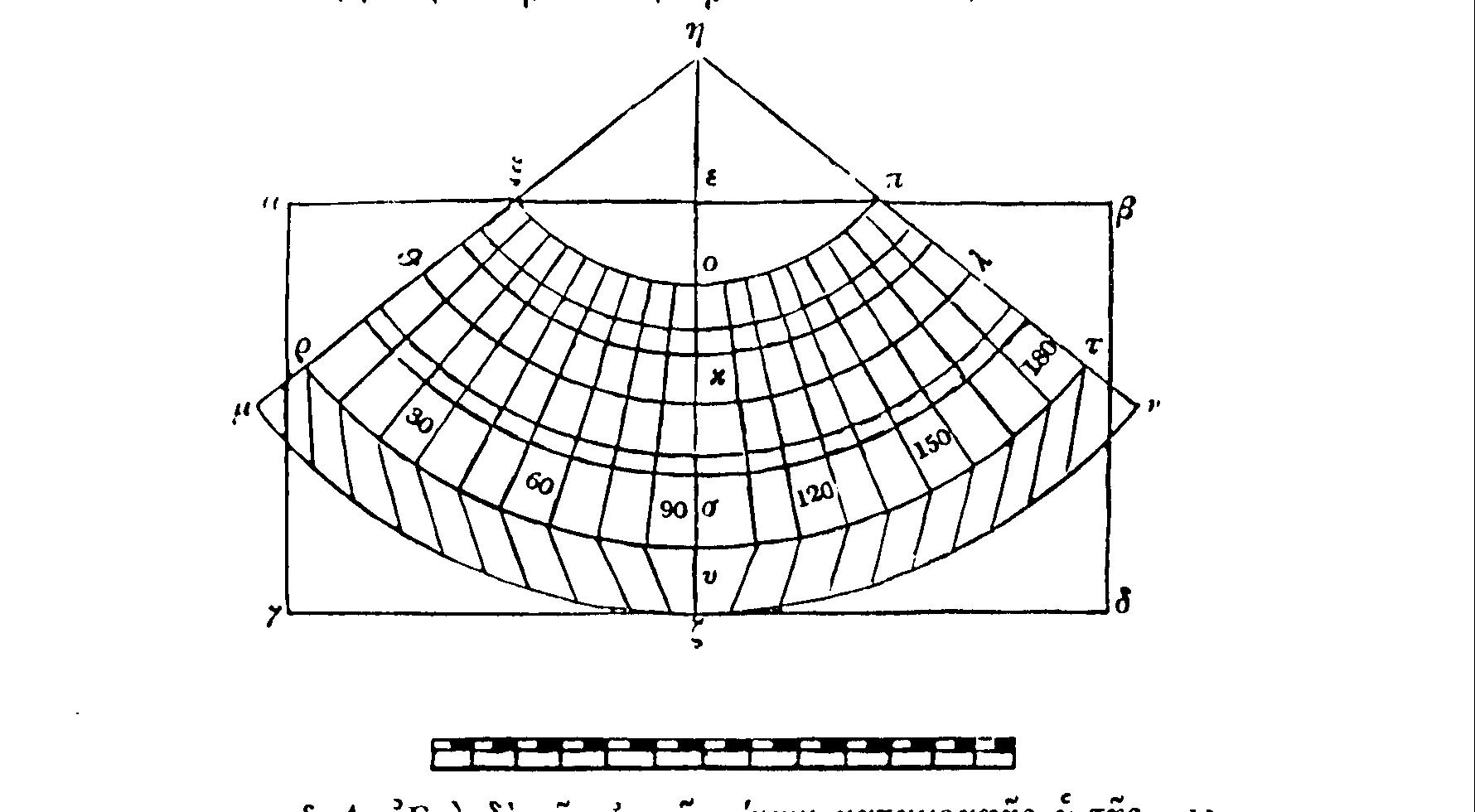
§1. As regards cartographic representation, our method of proportioning the separate parallels will be as follows. We will prepare a chart with the outline of an oblong, with right–angled parallel sides, to be called
a ß g d. The side a ß having, as near as possible, twice the length of side a g. The side a ß is to be placed at the top of the chart, representing the northern part of the map–making exercise.§2. Then, breaking the side
a ß into two halves, we will attach to it a vertical, straight line e z, arranged to be at right angles. Subsequently from this length, (e z), it is to be combined, at the midway point, with one more straight, vertical line to be known as e h. And let e h become thirty–four such parts, and h z will become by right, one hundred and thirty–one and five twelfths of such parts. Centring on h, at a distance of 78 parts separating the point itself, along the line h z, we will inscribe an arc, representing the parallel of Rhodes, to be known as q k l.L
3. Then in order that the limits of longitude may be gathered together into hourly interludes on each side of k, taking from h z from the middle meridian a distance of four intervals, which is five parts on the parallel through Rhodes, because as near as possible this is its ratio to the great circle, and as many as eighteen, parts on both sides of k, in relation to the arc q k l, we have a device, through being able to be connected from the point h, of distinguishing the meridians at intervals of one third part of an hour, and consequently marking off the boundaries denoting the extremity (of the known world) by h q µ and h l n.§4. In accordance with this the interval through Thule can be inscribed, separated from
h in the line h z, by fifty two parts, thus marked x o p; similarly, emanating from h, the equinoctal line of one hundred and fifteen parts representing r s u, and the southernmost, opposite to that through Meroe, at an interval from h of one hundred and thirty–one degrees and twenty–five minutes, represented as µ u n.§5.
r s τ, matched as a ratio against x o p is as one hundred and fifteen against fifty–two, being the same ratios as the relevant parallels on the sphere.§6. Since the sum of each part of
h s is taken to be one hundred and fifteen, of which the line h o is fifty–two, while h s is to h o what the arc r s u is to x o p? The distance of the meridian through Thule, as against that through Rhodes, represented by o k, will now have to be taken care of, being twenty–seven parts, and that between the one through Rhodes and the equator, being k s or thirty–six parts, also that from the equator to the opposing one through Meroe, represented by s u, of sixteen and five–twelfths parts. Further the last one is o u, being the extreme latitude of seventy–nine and five–twelfths parts, or to the nearest, eighty, the distance of the median longitude, represented by q k l will be one hundred and forty–four, in accordance with scientific standards having been laid down. These, as near as possible, also have the argument of forty thousand stadia for the total latitude and seventy–two thousand stadia for the total longitude for the parallel of Rhodes. And the remaining parallels we can inscribe by returning to the use of the central point h. as can the intervals of the lines emanating from s, by using the same intervals from the equator that have been noted.§7. For us to draw the lines of the meridians straight through to the parallel µ
u n will not be allowed, but only until they reach the equator, r s u. Then the periphery, µ u n, each half broken up into ninety equally divided segments, taking, as an example, that through Meroe, to join on to alternate straight lines of the meridians coming through from the equator, it will be seen to appear that at the equator the meridians partake in a deflection, thus have the lines r j and τ c.§8. Remaining, insofar as is convenient, is the putting in their proper positions the places to be marked. We should obtain a narrow ruler, equal in length to
h z or h s, and embodying h as its centre, so that it being moved around the whole length of the inscribed map, because of a notch cut out around the region of the pole, it is able to accurately coincide with one of the many straight meridians. We break this side up by applying in full to the line h z, one hundred and thirty–one and five twelfths parts, or to the line h s, one hundred and fifteen. We then mark it for ourselves with numbers, doing so from the end beginning at the equator. From these it is possible to draw the parallels, and so that we might not confuse with a swarm of place names, the meridian lines will everywhere separate the inscriptions.§9. Therefore having broken up the equator into twelve hours and one hundred and eighty degrees, and having placed alongside the numbers commencing from the most western meridian, we will always bring forward the side of the ruler to the degree of longitude having been indicated. And through the divisions on the ruler arriving at the indicated position of latitude, we will make the correct mark for each position, demonstrating in the manner as from the sphere.
10 Yet we would make a better resemblance, and in a way, a better fitted map of the known world, if we would hold the meridian lines in our minds eye as a point on the surface of a sphere. As being meridian lines bisecting parallel lines, before our eyes, their length and breadth on the earth having been resolved into two equal parts, and yet the centre of the sphere in order that the extremes that lie opposite are accepted by the eye in a similar manner.
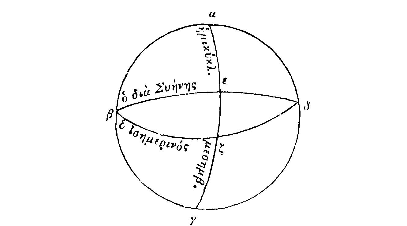
§11. First in determining how great the inclination of the parallel circles and of the plane through the point of intersection and of the centre of the sphere at right angles to the middle of the length of the meridian, for example see the great circle, (figure II), marking off the hemisphere being revealed by
a ß g d, and bisecting this hemisphere, the semicircular meridian, a e g, while before the eye bisecting this, through e, a similar semicircle, the great circle of the parallel latitude is drawn at right angles to a e g, being ß e d, the plane of this as revealed, lies within the minds eye.L
12. Having comprehended this the circumference of e z, of twenty–three and five sixths degrees, (for by this much distance the equator is placed, as near as possible, from the latitude through Syene), being drawn through z the semicircle of the equator, being ß z d. Consequently, having been inclined, the equatorial plane and of the other parallels will appear, to the minds eye, in essence to the circumference of e z twenty–three and five sixths degrees.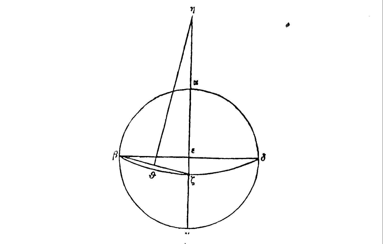
§13. With regard to what is now shown, (figure III), in
a e z g and ß e d as entities in themselves instead of just semicircles, ß e has the argument to e z that ninety has to twenty–three and five sixths.§14. And
g a, being extended, falls through the centre from which ß z d is drawn as an arc, to h. To find out the argument depending on h z as to e ß, a direct line joining together z and ß and itself being divided in two parts at q, and joining together q and h clearly being able to come down to ß z.§15. Now since it is laid down that the straight ß
e is ninety and also e z is twenty–three and five sixths, the line, ß z, connecting their lower extremities will be ninety–three and one tenth, the angle ß e z one hundred and fifty and one third, since two have to be exactly three hundred and sixty, the other angle, q h z, is of itself twenty–nine and two thirds.§16. And it is through this that the argument of
h z to z q is as one hundred and eighty–one and five sixths to forty–six and eleven twentieths. And the straight line q z has forty–six and eleven twentieths in relation to ninety of the straight line ß e. Therefore we will have the straight line ß e at ninety, z e at twenty–three and five sixths and the straight line h z at one hundred and eighty one and five sixths and h the base point from which all parallels are to be drawn upon a plane surface.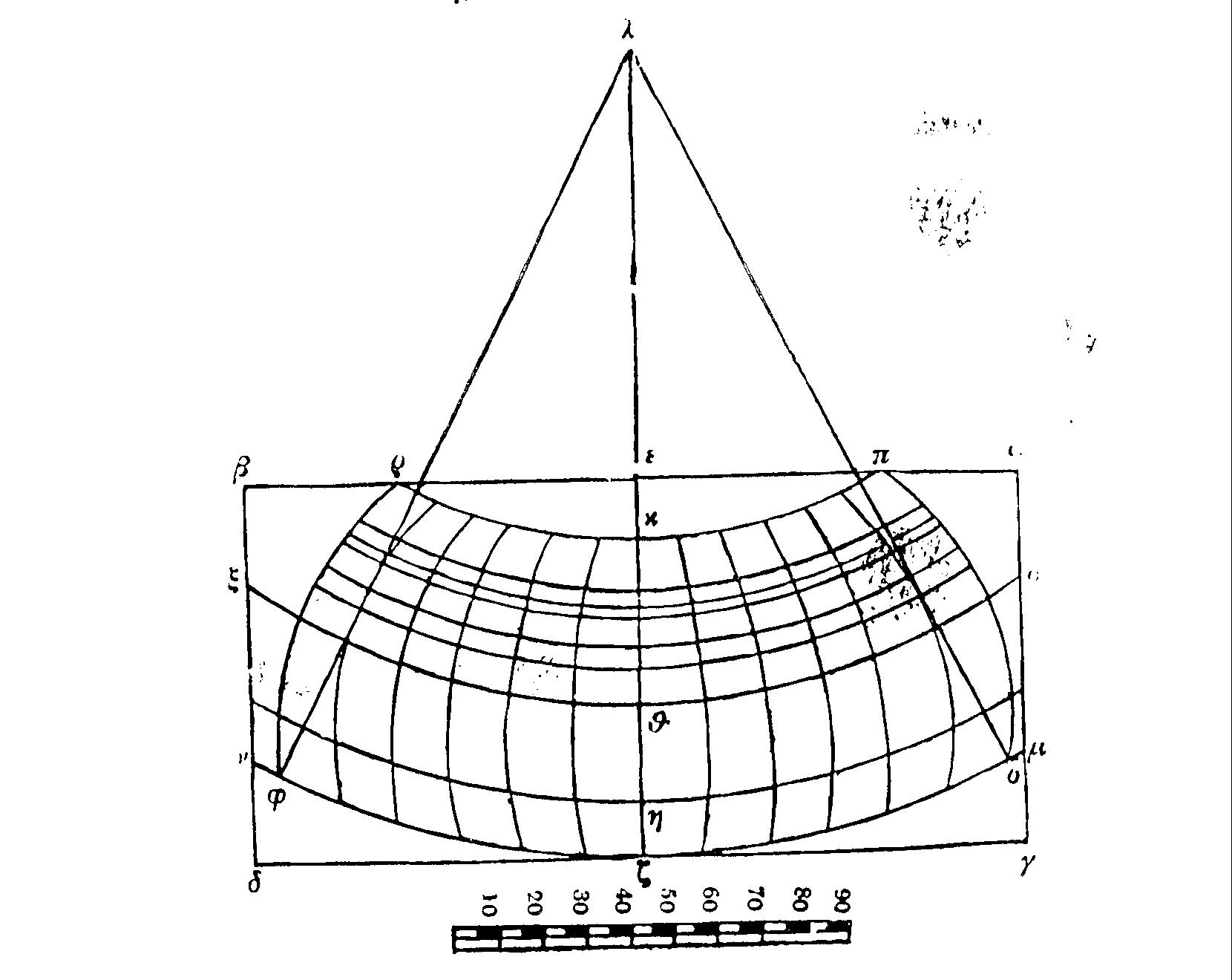
§17. Having grasped all, let us lay down again the diagram
a ß g d, (figure IV), similarly having a ß double the length of a g, with a e and e ß equal, and e z at right angles to them. Having divided the straight line e z into ninety parts, the fourth part of a circle, mark off z h at sixteen and five twelfths degrees, h q at twenty–three and five sixths degrees, h k at sixty–three of the same, and of h, as lying on the equinoctial line, and while q has, although not shown through Syene, as near as possible between the parallels of latitudes. z though not drawn, marking off the boundary of southern parts, and opposite that through Meroe. k, though not drawn, marking off the boundary to the northern parts and through the island of Thule.§18. And indeed extending a straight line
h l, of itself one hundred and eighty–one and five sixths portions [or to the nearest, one hundred and eighty one], or even one hundred and eighty, (for this will not make a great difference to the map itself). With the centre l, at the intervals of z, q and k, inscribe the semicircles p k r, x q o and µ z n.§19. Well then, as befits the matter, having observed the inclination of the parallels towards a plane surface, within the minds eye in this way, when it is compelled to lower its axis to
q and being at right angles to the plane surface of the map, in order to allow it to be made completely visible equally at the extremes of the inscriptions drawn opposite to each other.L
20. But in order that the longitude is commensurate with the latitude, (since on the sphere the great circles has five parts, the parallel through Thule, as near as possible, is two and a quarter, and through Syene four and seven twelfths, and through Meroe four and five sixths). It is necessary on each side of the meridian z k let us place eighteen meridians, each occurring every third part of an equatorial hour, to fill completely the whole of the longitudes encompassing the semicircles.§21. Being able we will take from out of each of these three parallels segments equivalent to one third or five degrees. Making incisions on the line
e z, on which we have ninety, at two and one fourth segments from k, at four and seven twelfths from q and at four and five sixths from z.§22. Then drawing out from each of these three marked points semicircles as being for the remaining meridians, as the marking off of longitude
s u u and j c y, we will be able to fill in for the remaining parallels, with the same centre l, the segments being at intervals on z k in relation to the intervals from the equinox.§23. A greater similarity to the likeness of inscription on a sphere as opposed to previous methods is at once obvious.
§24. When a sphere remains motionless and is not revolving, there, of necessity, it also corresponds with a map and the eye is turned of itself to the middle of the inscribed map, to a meridian through which, on to the plane surface of the inscribed map, the axis of vision would represent, as of a straight appearance. All those on each being distorted in relation to the concave appearance and this is more pronounced the fuller the difference of the concavity, as the relative proportions will be observed amongst the arcs, and the relation of semicircular parallels to one another, not only at the equator or that through Thule, done to preserve relative argument, but from the others as it is allowed especially the nearest, just as it was done to contemplate proving.
§25. And of the latitude alone towards the longitude alone is not only the same as the parallel drawn through Rhodes, just as it does towards all of the others.
§26. For if we should carry across the straight line
s w u as in the previous figure, the hemisphere q w it makes clearly a smaller argument to z s and k q, to that which properly belongs to the argument of this map, which is taken entirely by q u, bearing in mind the equinox.§27. For if we were to make it be in relation to
k z extended latitude, then z s and k u will be greater than relating to z k, as q u. If we take z s and k u to agree with z h, just as q u is to q n.§28. Therefore while this method would have the advantage over the former; this question about map making is academic, since really it makes for the ruler having to be carried over and applied, even if one only parallel is drawn and divided into segments, to register each of the locations. Here there is no longer need for this, because of the meridian line becoming greater when moving away from the middle, it is necessary that all the circles be drawn in, and points falling between the quadrants and encompassed by whole sides, through taking into account known data and proceeding from there.
§29. Since this is so, for me, at least here and elsewhere, the better and more laborious is to be preferred to the inferior and more easy, nevertheless it is necessary for both methods to be kept in working condition, for the sake of all those more inclined to this method through being weighed down by indolence.
§30. The solstice of Meroe is of such a kind, four and five sixths. It has the ratio of thirty to twenty–nine.
§31. The solstice through Syene is of such a kind, four and seven twelfths. It has the ratio of sixty to fifty–five, as well as of twelve to eleven.
§32. The solstice through Rhodes is of such a kind, it has the ratio to one fourth.
§33. The solstice through Thule is of such a kind, two and a quarter. It has the ratio of twenty to nine.
.oOo.